
Virtual tour
360° Virtual Tour Technology
Spacer 360° represents cutting-edge technology that enables virtual exploration of various objects, interiors, or areas as if one were physically present. Utilizing the iGUIDE device, we conduct photographic sessions and scan spaces, accurately reproducing them in a three-dimensional form.
The 3D virtual tour presentation allows complete immersion in a specific location, enabling detailed examination of each element, object or space. It not only saves time but also provides convenience and comfort. Users can transport themselves to any place without leaving their homes and revisit it multiple times.
360° Virtual tours serve as excellent promotional tools on the internet for various industries. These include real estate management, hotels, restaurants, wedding venues, museums and many other commercial spaces. This modern way of presenting properties attracts the attention of potential clients. It’s allowing them to thoroughly acquaint themselves with the object and visually test it before making decisions.
This solution is also ideal for public institutions aiming to interactively showcase their interiors, encouraging and facilitating real visits. Thanks to the virtual tour, potential clients can discover the charms of a particular place and decide on a physical visit.
iGUIDE Technology
We leverage Planitar’s technology, incorporating a 360° camera combined with a 2D time-of-flight laser scanner with an extensive range. The fusion of 360° images with a 2D laser point cloud enables not only precise construction of room projections but also measurements in 3D space, eliminating the need for a 3D grid.
Website and Google Street View Integrations
We offer a comprehensive set of options for efficiently managing your virtual tour. Depending on the property and your needs, you can share the tour on platforms such as Facebook or Instagram. You can embed it on your website, and with our support, add it to your Google Street View business listing.
Quality and Full Control
Our 360° camera captures images at an impressive resolution of 6720×3360. The ability to process images before transforming them into a 360° tour allows us to achieve even better visual effects. This not only improves quality but also enables the concealment of unwanted elements without the need for additional panoramas. Thus, we provide complete control over the final presentation.
Advanced Measurement Tools
Our device is equipped with an advanced laser lidar, enabling dynamic measurements of every space during a virtual tour, as many times as needed. This invaluable tool significantly speeds up and simplifies the work of architects, designers, contractors and civil engineers.
Fast and precise live space measurements also provide prospective tenants or property owners easy access to the dimensioning process. This allows them to make a preliminary assessment of available space and estimate the costs of furniture installation. It’s increasing the presentation’s attractiveness to potential users.
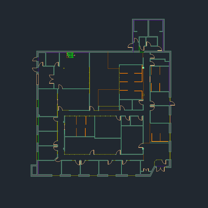
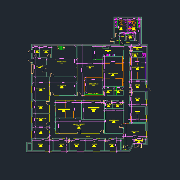
DWG Floor Plans
Our new service is tailored for engineers, architects and designers. They understand the challenges of collecting and reproducing data on technical drawings. This task always carries the risk of overlooking crucial details or making errors that can lead to problems and additional costs.
Imagine a service that helps you avoid these difficulties. We introduce our latest solution, eliminating these problems and significantly speeding up the design process.
Within just 48 hours of scanning, we will provide you with an accurate floor plan of a building. You no longer need to worry about missing dimensions or forgotten elements. Our advanced measurement tools guarantee that you receive a complete floor plan in DWG format, precise and ready for immediate use.
Additionally, our service offers a virtual tour, allowing you to explore the investment at any time. This enables you to see how individual elements fit together. It shows how the space is utilized and how it can be optimally planned. This provides a significant advantage for your design process.
Key features of DWG floor plans include:
- Standard AIA (American Institute of Architects) layers.
- Annotations, including labels, area sums, objects, dimensions, etc.
- LOD 200 (Level of Development)
- 3D Tour: Explore the object virtually
See a sample implementation:
Do you want your prospective clients to get to know your property?
Leave it to the professionals, that is us!
